
Plaque on the Bunhill Fields Meeting House (Society of Friends), off Banner Street, EC1

See TQ3282 : Bunhill Fields Meeting House (Society of Friends), off Banner Street, EC1. © Copyright Mike Quinn and licensed for reuse under this Creative Commons Licence . Submitted via Geograph
- religious sites
- city
- town centre
- geograph
Plaque, Toll House

The plaque is on the toll house. For a view of the building NN8621 : Toll House, Crieff © Copyright Maigheach-gheal and licensed for reuse under this Creative Commons Licence . Submitted via Geograph
- housing
- dwellings
- geograph
- roads
- road transport
- suburb
- urban fringe
- toll house
The Spirit of Heysham
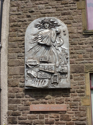
To be found on the wall of the Institute on Main Street © Copyright Alexander P Kapp and licensed for reuse under this Creative Commons Licence . Submitted via Geograph
- public build...
- geograph
Plaque, St Peter's Church

This plaque is above the main door to the church. For a view of it in situ SU1156 : Door, St Peter's Church © Copyright Maigheach-gheal and licensed for reuse under this Creative Commons Licence...
- village
- rural settlement
- religious sites
- geograph
Plaque, The Colthurst Hall, Richhill

It is located here H9448 : Colthurst Hall, Richhill © Copyright Kenneth Allen and licensed for reuse under this Creative Commons Licence . Submitted via Geograph
- public build...
- geograph
Plaque, Ensor Masonic Hall

It is located here H9052 : Ensor Masonic Hall, Loughgall © Copyright Kenneth Allen and licensed for reuse under this Creative Commons Licence . Submitted via Geograph
- public build...
- geograph
Ian Kennedy plaque, Helen's Bay

Self-explanatory plaque in this wood J4581 : Woodland near Helen's Bay (1). © Copyright Albert Bridge and licensed for reuse under this Creative Commons Licence . Submitted via Geograph
- paths
- woodland
- forest
- people
- events
- woodland
- geograph
- suburb
- urban fringe
- helens bay
- clandeboye avenue
The Museum of British Resistance Organisation (BRO) - plaque

For a wider view of this location see > Link. The Museum - it is situated in Nissen Huts adjoining the 390th Bombardment Group Memorial Air Museum Control tower at Parham Airfield > Link - houses...
- educational sites
- defence
- military
- museum
- geograph
Blue plaque at Edgeley Park, Stockport
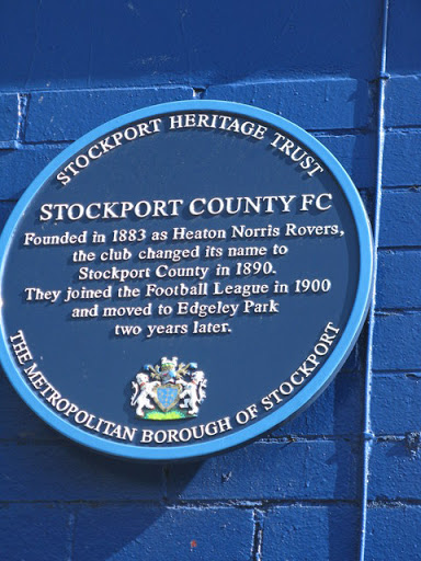
The blue plaque at Edgeley Park, Stockport. This is on the road side of the Hardcastle main stand, adjacent to the Players and officials entrance. © Copyright Dave Pickersgill and licensed for...
- edgeley park
- geograph
- sport
- leisure
- historic sit...
- stockport
Plaque on the Guildhall

Mounted high above the front portico of the Guildhall, this stone plaque records the gift of the building by the second Earl of Radnor to the city of Salisbury in 1794 for the "Use of the Mayor...
- guildhall
- public build...
- geograph
- inscribed plaque
- city
- town centre
- historic sit...
- stone plaque
Plaque, Cloughaneely Club Hall

It reads, "Arus Chloich Cheann Fhaola, - tógadh 1910, agus ath-uair (iar a loisgeadh* ag Gallaibh) 1923" The English translation is "Cloughaneely Club - built 1910, and rebuilt (after it...
- public build...
- geograph
Plaque marking site of Queen Elizabeth Grammar School for Boys, Carmarthen
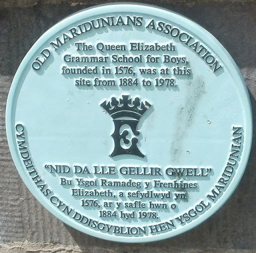
The Old Maridunians Association plaque is at the entrance Link to Parc Myrddin. © Copyright Jaggery and licensed for reuse under this Creative Commons Licence . Submitted via Geograph
- historic sit...
- geograph
Plaque on the bridge

This plaque is attached to SU1430 : Scamell's Bridge, a former railway bridge that now carries Nelson Road over the River Avon. Note how the line spacing varies, getting wider towards the...
- old bridge
- iron bridge
- railways
- geograph
- railway bridge
- suburb
- urban fringe
- roads
- road transport
- rivers
- streams
- drainage
Plaque on Lower Eirw Bridge, Trehafod

The plaque is on this bridge Link over the River Rhondda. © Copyright Jaggery and licensed for reuse under this Creative Commons Licence . Submitted via Geograph
- bridge
- roads
- road transport
- geograph
Plaque, Teach Pobail Cholmcille

It is located here B8330 : St Columcille's RC Church, Cloghernalavagh Cnoc Fola = Bloody Foreland © Copyright Kenneth Allen and licensed for reuse under this Creative Commons Licence . Submitted...
- religious sites
- geograph
McFadzean VC plaque, Belfast

Self-explanatory memorial plaque on what is now a dental surgery, at the corner of Cregagh Park and the Cregagh Road, in memory of Billy McFadzean VC. The citation reads No. 14/18278 Pte....
- memorial
- belfast
- cregagh road...
- people
- events
- geograph
- victoria cross
- suburb
- urban fringe
- world war 1
Plaque, Loch an Iuir

English translation, "Erected in honour of the men who won their livelihood from the lime" From Wikipedia article on the village "Loch an Iúir was once a major source of agricultural...
- village
- rural settlement
- park and pub...
- public build...
- geograph
Wall plaque, Loughanure
![The English translation is, "This was erected to commemorate the first house that [he?] lived in in Loughanure" It is located here B8116 : Wall with plaque, Loughanure © Copyright Kenneth Allen...](http://lh3.googleusercontent.com/BMr-nWluGPaCeb72S3_wIgY3g0m3_xzgMNDTONpVR8zoNfGH2Gl6qGCFtwrXmA9ExI8jvA0eH0eqWoL7x6-Y1OnH_HtW)
The English translation is, "This was erected to commemorate the first house that [he?] lived in in Loughanure" It is located here B8116 : Wall with plaque, Loughanure © Copyright Kenneth Allen...
- park and pub...
- geograph
The Elmwood Hall, Belfast (13)

The memorial, in the floor of the loggia J3372 : The Elmwood Hall, Belfast (11) marking the death, on 31 January 1869, of Robert Corry. Robert Corry was, to the best of the knowledge the father...
- memorial
- public build...
- belfast
- loggia
- elmwood hall...
- floor
- geograph
- sport
- leisure
- suburb
- urban fringe
- church (alte...
Plaque on Alkerton House, Cricklade

See: SU1093 : Alkerton House, Cricklade © Copyright Philip Halling and licensed for reuse under this Creative Commons Licence . Submitted via Geograph
- historic sit...
- geograph