
Information plaque on May Bridge

This small yellow plaque on the western buttress of ST9924 : May Bridge gives the bridge number, R/12/65, and the year of building as 1936. © Copyright Seo Mise and licensed for reuse under this...
- village
- rural settlement
- bridge
- ebble
- ebbesbourne wake
- geograph
- roads
- road transport
- rivers
- streams
- drainage
Plaque, Bunting's

For a wider view of the cottage on which the plaque is set ST9923 : Bunting's, Ebbesbourne Wake © Copyright Maigheach-gheal and licensed for reuse under this Creative Commons Licence ....
- village
- rural settlement
- housing
- dwellings
- thatched cottage
- ebbesbourne wake
- geograph
Raoul Wallenberg Place

Raoul Wallenberg Place "Raoul Wallenberg's mission of mercy on behalf of the United States behind enemy lines during World War II is unprecedented in the history of mankind. He is responsible...
- holocaust
Plaque at north end of High Level Bridge
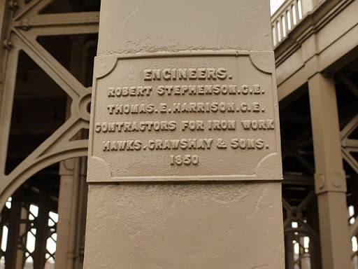
The plaque reads: Engineers. Robert Stephenson C.E. Thomas E. Harrison C.E. Contractors for iron work Hawks, Crawshay & Sons. 1850 A second plaque was added recently documenting the...
- lowlands
- railways
- geograph
- city
- town centre
- roads
- road transport
Brown plaque on No56 Church Street, Padiham

Link © Copyright Alexander P Kapp and licensed for reuse under this Creative Commons Licence . Submitted via Geograph
- historic sit...
- suburb
- urban fringe
- geograph
Portstewart War Memorial (4) - plaque, Harbour Road, Portstewart
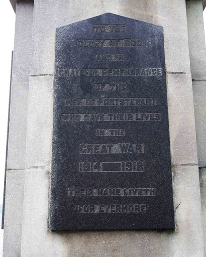
The plaque reads:- To the glory of God and in grateful remembrance of the men of Portstewart who gave their lives in the Great War 1914 - 1918. Their name liveth for evermore". See also:- C8138 :...
- religious sites
- geograph
- city
- town centre
- historic sit...
- war memorial
Portstewart War Memorial (3) - plaque, Harbour Road, Portstewart

This plaque is dedicated to the men of the 508th Parachute Infantry Regiment, 82nd Airborne Division of the United States Army. They were stationed at Camp Cromore from the 9th January to the 11th...
- religious sites
- geograph
- city
- town centre
- historic sit...
- war memorial
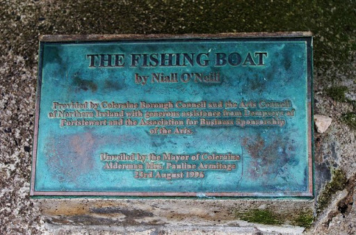
The Fishing Boat sculpture (4) - plaque, Harbour Road, Portstewart

One of the two plaques at the foot of the sculpture. See also:- C8138 : The Fishing Boat sculpture (1), Harbour Road, Portstewart. © Copyright P L Chadwick and licensed for reuse under this...
- city
- town centre
- sculpture
- geograph
The Fishing Boat sculpture (3) - plaque, Harbour Road, Portstewart
One of the two plaques at the foot of the sculpture. See also:- C8138 : The Fishing Boat sculpture (1), Harbour Road, Portstewart. © Copyright P L Chadwick and licensed for reuse under this...
- city
- town centre
- sculpture
- geograph
The Ropley Race Stones

This stone, actually a piece of concrete, lies on the edge of the recreation ground. The plaque reads:- THE ROPLEY RACE STONES Extract from "Annals of Old Ropley" by Marianne Hagen 1929 "A dispute...
- lowlands
- village
- rural settlement
- geograph
- closeup
- historic sit...
Plaque on Millennium Stone

Plaque on Millennium Stone in Treeleck Grange. See: SO4901 : Millennium standing stone, Trelleck Grange © Copyright Philip Halling and licensed for reuse under this Creative Commons Licence...
- historic sit...
- geograph
Willowbrook Road bridge - date plaque
![The plaque is on the north spandrel of the bridge TQ3377 : Willowbrook Road bridge. It reads: SCC [Surrey Canal Co.] Hill Street Bridge AD 1870. Presumaby Hill Street was the old name for...](http://lh3.googleusercontent.com/ZUArMiPO3OvBScobuUfA_BDye0e3Z_tRCAx3WDPccGhfMxlxg-qyj6roDLCCy8x6N7tPt0qVwzNu-9rg-utKQ9fdds9rJA)
The plaque is on the north spandrel of the bridge TQ3377 : Willowbrook Road bridge. It reads: SCC [Surrey Canal Co.] Hill Street Bridge AD 1870. Presumaby Hill Street was the old name...
- geograph
- roads
- road transport
- 1870
- surrey canal
Plaque, Bolton Church

A plaque on the outer side of the kirkyard wall referring to members of Robert Burns' family that are buried here. © Copyright Richard Webb and licensed for reuse under this Creative...
- religious sites
- historic sit...
- geograph
Plaque on the Battle of Roslin monument
The plaque marks the erection of the monument in 1994 by the Roslin Heritage Society - see Link for photographs from the opening ceremony. © Copyright Jim Barton and licensed for reuse under...
- historic sit...
- geograph
JW Carey plaque, Belfast

A plaque, at Knockdene Park, commemorating Joseph William Carey, painter Link . See also J2058 : Kilwarlin Moravian Church. © Copyright Albert Bridge and licensed for reuse under this...
- belfast
- people
- events
- geograph
- suburb
- urban fringe
- blue plaque
Plaque on porch of St. Joseph's Church, Kilclaren

The plaque says that "This chapel was erected by the Revd. A. Connellan P.P. A.D. 1863." The plaque is on the exterior wall of the porch. R5689 : St. Joseph's Church, Kilclaren. © Copyright P...
- village
- rural settlement
- religious sites
- geograph
Plaque on the bridge at Bridgnorth
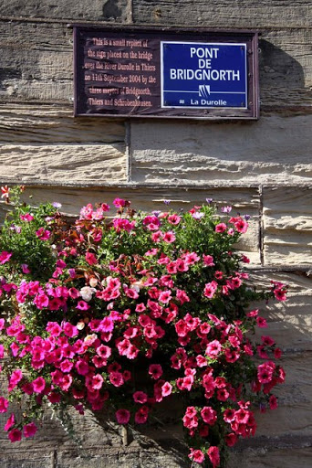
The sign is a replica of the one on the bridge over the River Durolle in Thiers, Bridgnorth's twin town. © Copyright Steve Daniels and licensed for reuse under this Creative Commons Licence...
- public build...
- geograph
Plaque on the shelter
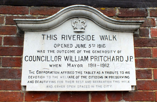
This plaque, fixed to the end of the SU1429 : Park shelter, commemorates the opening of the Riverside Walk on the 5th of June 1916. © Copyright Seo Mise and licensed for reuse under this Creative...
- paths
- park and pub...
- geograph
- footpath
- park shelter
Text, Tumbling Well

The biblical text that is inscribed on a marble tablet within the well shown in NZ2305 : Tumbling Well, Middleton Tyas © Copyright Maigheach-gheal and licensed for reuse under this Creative...
- village
- rural settlement
- middleton tyas
- well
- geograph
- water resources
Story on the post

A potted history of the Kennet and Avon canal can be found on the side of the information display board. © Copyright Bill Nicholls and licensed for reuse under this Creative Commons Licence...
- village
- rural settlement
- explanatory plaque
- educational sites
- information plaque
- geograph
- historic sit...