Glebe Park
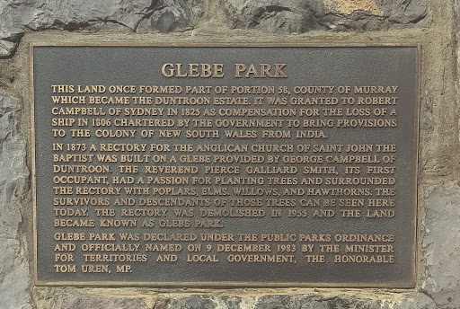
Plaque reads:
'Glebe Park
This land once formed part of Portion 58, County of Murray which became the Duntroon Estate. It was granted to Robert Campbell of Sydney in 1825 as compensation for the loss of a ship in 1806 chartered by the government to bring provisions to the colony of New South Wales from India.
In 1873 a rectory for the Anglican Church of Saint John The Baptist was built on a Glebe provided by George Campbell of Duntroon. The Reverend Pierce Gallard Smith, its first occupant, had a passion for planting trees and surrounded the rectory with poplars, elms, willows, and hawthorns. The survivors and descendants of those trees can be seen here today. The rectory was demolished in 1955 and the land became known as Glebe Park.
Glebe Park was declared under the public parks ordinance and officially named on 9 December 1983 by the Minister for Territories and Local Government, the Honourable Tom Uren, MP.'
Submitted By:@IanThorp