Caruthersville
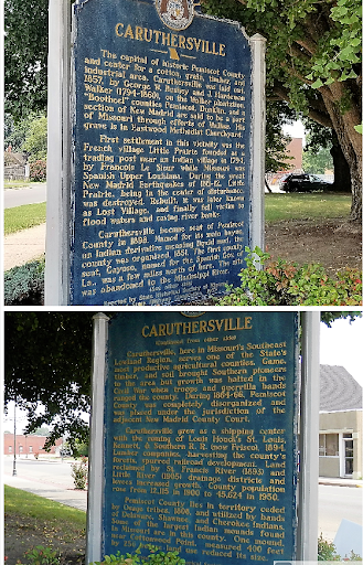
The capital of historic Pemiscot County and center for a cotton, grain, timber, and industrial area, Caruthersville was laid out, 1857, by George W. Bushey and J. Hardeman Walker (1794-1860), on the Walker plantation. "Bootheel" counties Pemiscot, Dunklin, and a section of New Madrid are said to be part of Missouri through efforts of Walker. His grave is in Eastwood Methodist Churchyard.
First settlement in this vicinity was the French village of Little Prairie founded as a trading post near an Indian village in 1794, by Francois Le Sieur while Missouri was Spanish Upper Louisiana. During the great New Madrid Earthquakes of 1811-12, Little Prairie, being in the center of disturbance, was destroyed. Rebuilt, it was later known as Lost Village, and finally fell victim to flood waters and caving river bank.
Caruthersville became seat of Pemiscot County in 1898. Named for its main bayou, an Indian derivative meaning liquid mud, the county was organized, 1851. The first county seat, Gayoso, named for the Spanish Gov. of La., was a few miles north of here. The site was abandoned to the Mississippi River.
Caruthersville grew as a shipping center with the coming of Louis Houck's St. Louis, Kennett, & Southern R.R. (now Frisco), 1894. Lumber companies, harvesting the county's forests, spurred railroad development. Land reclaimed by St. Francis River (1893) and Little River (1905) drainage districts and levees increased growth. County population rose from 12,115 in 1900 to 45,624 in 1950.
Pemiscot County lies in territory ceded by Osage tribes, 1808, and utilized by bands of Delaware, Shawnee, and Cherokee Indians. Some of the largest Indian mounds found in Missouri are in this county. One mound, near Cottonwood Point, measured 400 feet by 250 before land use reduced its size.