
Pier plaque, Rathmullan

Pictured here C2927 : Rathmullan, near the seafront See close-up view C2927 : Pier plaque (close-up) © Copyright Kenneth Allen and licensed for reuse under this Creative Commons Licence...
- geograph
- historic sit...
- docks
- harbours
Brye House

Submitted by Sheila Paske.
- auburn
- brye
- california
Entrance of Sheriff Court, Linlithgow
The building is shown in NT0077 : Sheriff Court, and, in that picture, the entrance is at the right. In the present photograph, the plaque bears a representation of the Regent Moray, who...
- sheriff court
- linlithgow
- historic sit...
- geograph
William Logsdail plaque

Plaque on 19 Minster Yard Link © Copyright Richard Croft and licensed for reuse under this Creative Commons Licence . Submitted via Geograph
- historic sit...
- housing
- dwellings
- geograph
Barton Grange Farm plaque, Bradford-on- Avon

The plaque is on a wall near the Grade I listed Barton Farmhouse. Link © Copyright Jaggery and licensed for reuse under this Creative Commons Licence . Submitted via Geograph
- historic sit...
- geograph
Ards TT plaque, Comber

See J4874 : Ards TT memorial, Newtownards. Commemorative plaque, in Castle Street at the corner of High Street, along what was part of the course. The building is still a butchers shop....
- ards tt
- people
- events
- motor sport
- geograph
- city
- town centre
- comber
Plaque on the viaduct

The former railway viaduct is now used by a cycle and footpath. The various parts of the sign read "Scarborough and Whitby Railway, Scarborough - 20 miles Whitby - 1 1/2 miles. North Sea cycle...
- larpool viaduct
- paths
- railway line
- cycle and footpath
- viaduct
- railways
- geograph
- sport
- leisure
- ruswarp
- esk
The Brick Plaque, Featherstone Sculpture and Garden Area

© Copyright Bill Henderson and licensed for reuse under this Creative Commons Licence . Submitted via Geograph
- brick plaque
- park and pub...
- public build...
- geograph
John Macoun plaque, Magheralin
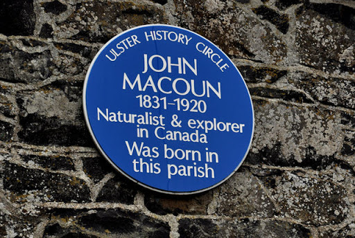
A plaque, on the New Forge Road, commemorating John Macoun - naturalist and explorer Link. © Copyright Albert Bridge and licensed for reuse under this Creative Commons Licence . Submitted via Geograph
- village
- rural settlement
- people
- events
- geograph
- magheralin
- blue plaque
Neglect Not Thy Opportunities

Plaque on ST4619 : The Post Office, East Street. © Copyright Mike Quinn and licensed for reuse under this Creative Commons Licence . Submitted via Geograph
- village
- rural settlement
- historic sit...
- geograph
Plaque, Ballymacreely Orange Hall

The following text is included, "Ballymacreely Orange Hall. Foundation stone laid by Miss Ena McVeigh, Ballycowan, Belfast. 14th January, 1928. Opened by Mrs James McConnell, Balloo...
- public build...
- geograph
Kirkwall: castle ruins plaque on the Lloyds TSB

Explaining why Castle Street is so named, this plaque gives a history of the site now occupied by the very unhistoric Lloyds TSB bank. It states: "Near this spot, facing Broad Street, stood,...
- bank (financ...
- city
- town centre
- historic sit...
- geograph
Entrance to Stepping Hill Hospital

Memorial stone set in a flower bed at the entrance to Stepping Hill Hospital. The plaque reads "This stone commemorates the establishment of Stockport NHS Foundation Trust on 1 April 2004....
- stone
- hospital
- memorial
- nhs foundation trust
- geograph
- health and s...
- flower bed
Plaque, Teconnaught Community Centre
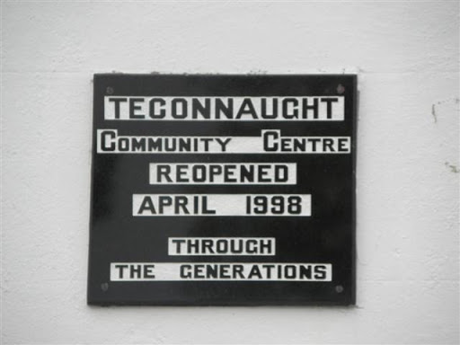
Pictured here J4348 : Teconnaught Community Centre © Copyright Kenneth Allen and licensed for reuse under this Creative Commons Licence . Submitted via Geograph
- educational sites
- public build...
- geograph
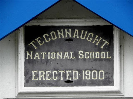
Plaque, Teconnaught National School
Pictured here J4348 : Teconnaught Community Centre © Copyright Kenneth Allen and licensed for reuse under this Creative Commons Licence . Submitted via Geograph
- educational sites
- geograph
A plaque marking the opening of the Barnstaple Urban Relief Road

© Copyright Roger A Smith and licensed for reuse under this Creative Commons Licence . Submitted via Geograph
- city
- town centre
- roads
- road transport
- geograph
Stone outside the current Heritage Centre, Cape Clear Island

This building obviously used to be the school, but is now a museum. Unfortunately it was closed for the season at the time of our visit. See also V9622 : The Heritage Centre, Cape Clear Island...
- heritage centre
- educational sites
- geograph
- school (former)
- islands
Plaque on gateway, The Pemberton Almshouses

Plaque on the gateway of The Pemberton Almshouses (see TL1507 : Gateway, The Pemberton Almshouses). It reads "These six Alms Houses were Erected & Endowed With Five Pounds Pr. Annum Each Out of...
- pemberton almshouses
- almshouses
- housing
- dwellings
- roger pemberton
- geograph
- city
- town centre
- grade ii listed
- st albans
- gateway
Plaque, Norham Clock

The plaque is at the base of the Millennium Clock. For a wider view NT8947 : Clock, Norham © Copyright Maigheach-gheal and licensed for reuse under this Creative Commons Licence . Submitted via Geograph
- village
- rural settlement
- clock
- park and pub...
- geograph
- norham
The Hepworth Wakefield - footbridge 1

Pedestrian access to the Hepworth from Thornes Lane, (where the car park for the gallery is located). The footbridge crosses the River Calder. Re the plaque in the pavement:-...
- educational sites
- art gallery
- famous person
- geograph
- human achievement