

Plaque, Wesleyan Methodist Chapel

It states that the building was erected in 1838 Pictured here H9293 : 1st Mayola Scout Group Hall, Castledawson © Copyright Kenneth Allen and licensed for reuse under this Creative Commons Licence...
- religious sites
- geograph
Plaque, Castledawson Protestant Memorial Hall
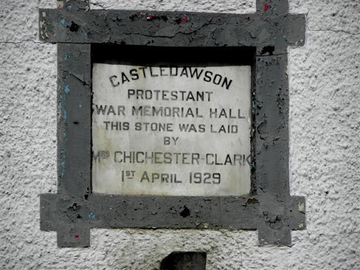
Pictured here H9293 : Castledawson Protestant Hall © Copyright Kenneth Allen and licensed for reuse under this Creative Commons Licence . Submitted via Geograph
- religious sites
- geograph
Plaque, Bellaghy Masonic Hall

Pictured here H9596 : Masonic Temperance Hall, Bellaghy © Copyright Kenneth Allen and licensed for reuse under this Creative Commons Licence . Submitted via Geograph
- public build...
- geograph
Plaque, Ladykirk and Norham Bridge

The plaque tells us that the bridge was built between 1885-7 by the Tweed Bridges Trust. © Copyright Maigheach-gheal and licensed for reuse under this Creative Commons Licence . Submitted via Geograph
- bridge
- geograph
- rivers
- streams
- drainage
- tweed
- roads
- road transport
- ladykirk
The Barbour memorial playings fields, Lisburn (2)
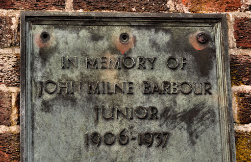
Part of the memorial plaque on the entrance gates J2763 : The Barbour memorial playing fields, Lisburn (1). © Copyright Albert Bridge and licensed for reuse under this Creative Commons Licence ....
- memorial plaque
- people
- events
- geograph
- sport
- leisure
- playing fields
- lisburn
- suburb
- urban fringe
D-Day commemorative trees, Innerleithen

Trees by the car park in Hall Street. A plaque on the stone plinth reads: Three Trees Were Planted By The Chairman Of Innerleithen Traquair & Glen Community Council On The 6th June 1994...
- park and pub...
- commemorativ...
- geograph
Rosamund Praeger plaque, Holywood

A plaque, in Hibernia Street, commemorating the sculptor Rosamund Praeger Link. Her works include Johnny the Jig J3979 : "Johnny the Jig", Holywood (1). See also J4079 : Praeger family grave,...
- people
- events
- geograph
- city
- town centre
- blue plaque
- holywood
Plaque, the Boyne Bridge, Belfast

A plaque, on the Boyne Bridge J3373 : The Boyne Bridge, Belfast marking its rebuilding in 1936. © Copyright Albert Bridge and licensed for reuse under this Creative Commons Licence . Submitted via Geograph
- bridge
- belfast
- people
- events
- geograph
- city
- town centre
- roads
- road transport
War Memorial, Preston

The war memorial plaque is set into the wall of the village hall. For a wider view of the building NT7957 : Village hall, Preston © Copyright Maigheach-gheal and licensed for reuse under...
- village
- rural settlement
- public build...
- village hall
- geograph
- war memorial
Memorial plaque, Preston

The plaque is set into the wall of the village hall. For a wider view of the building NT7957 : Village hall, Preston © Copyright Maigheach-gheal and licensed for reuse under this Creative...
- village
- rural settlement
- public build...
- village hall
- geograph
A plaque on the Anwoth and Girthon Millennium Cairn

This plaque lists the ministers of the United Charge of Anwoth and Girthon Parish Church from 1975 to the present day. For a view of the cairn, see NX5855 : A Millennium Cairn in the...
- lowlands
- geograph
- millennium cairn
A plaque on the Anwoth and Girthon Millennium Cairn

This plaque lists the ministers of Girthon Church since The Reformation (1560). For a view of the cairn, see NX5855 : A Millennium Cairn in the Boreland Hills. © Copyright Walter Baxter...
- lowlands
- geograph
- millennium cairn
A plaque on the Anwoth and Girthon Millennium Cairn

This plaque lists the ministers of Anwoth Church since The Reformation (1560). For a view of the cairn, see NX5855 : A Millennium Cairn in the Boreland Hills. © Copyright Walter Baxter...
- lowlands
- geograph
- millennium cairn
John Hewitt plaque, Belfast
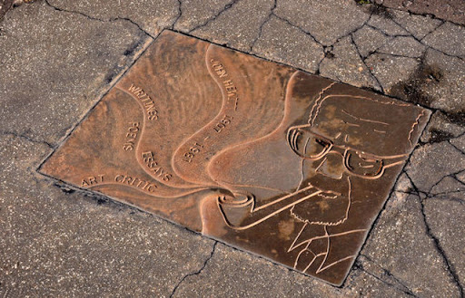
A plaque, in the footpath, at the Crumlin Road end of Agnes Street commemorating the poet John Hewitt Link. He was born nearby at Cliftonpark Avenue and attended Agnes Street Methodist Primary...
- people
- events
- belfast
- suburb
- urban fringe
- geograph
Seipeil Dhonnain (St Donnan's Chapel)

A bilingual notice gives the history of the ruined chapel founded by Donnan on the shore of Loch Kishorn. © Copyright Tiger and licensed for reuse under this Creative Commons Licence ....
- religious sites
- geograph
Pier plaque

The text is in Irish and English, the latter includes the inscription, "Rathmullan Pier reconstructed for Donegal County Council by the Commissioners of Public Works Viaduct 1934 Pier Head 1957"...
- geograph
- docks
- harbours
"The Flight of the Earls" plaque, Rathmullan

Basically the text includes the words, "The Flight of the Earls 1607 - 2007. The three Gaelic chieftains O'Nelll, O'Donnell and Maguire bid farewell to their people as they bound a ship...
- people
- events
- park and pub...
- geograph
Plaque, Quayside buildings
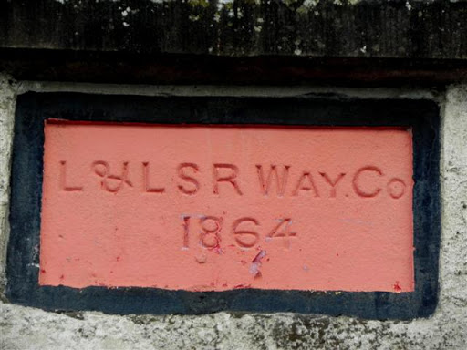
The inscription reads, "L & L S R Way Co 1864" It stands for Londonderry and Lough Swilly Railway Company - more at Link Pictured here C2221 : Quayside buildings, Ramelton © Copyright...
- geograph
- docks
- harbours
Windgap Hill Amenity Area - commemorative plaque, Dublin Road, Kilkenny

The plaque reveals the amenity area was opened in June 1998. S5155 : Windgap Hill Amenity Area, Dublin Road, Kilkenny. © Copyright P L Chadwick and licensed for reuse under this Creative...
- park and pub...
- suburb
- urban fringe
- geograph
"The Fid" plaque, Moville

It is in Irish, English and French and located here C6138 : The pier, Moville The English text includes the following wording, "The Fid Carved from a single oak. Over the 19th and 20th centuries...
- historic sit...
- geograph