
Plaque, The Town Clock and Sessions House

It is located here H4447 : Gifts & Things, Fivemiletown © Copyright Kenneth Allen and licensed for reuse under this Creative Commons Licence . Submitted via Geograph
- historic sit...
- geograph
Plaque, Aughentaine National School

Pictured here H4851 : Aughentaine National School © Copyright Kenneth Allen and licensed for reuse under this Creative Commons Licence . Submitted via Geograph
- educational sites
- geograph
Plaque, Fivemiletown Community Development

It is located here H4447 : The Butter Market, Fivemiletown © Copyright Kenneth Allen and licensed for reuse under this Creative Commons Licence . Submitted via Geograph
- historic sit...
- geograph
The Cross-Shaft information

Plaque informing of the history of the Cross-Shaft near Stancombe. See: SO8906 : The Cross-Shaft © Copyright Philip Halling and licensed for reuse under this Creative Commons Licence ....
- historic sit...
- geograph
Ottilie Patterson plaque, Comber
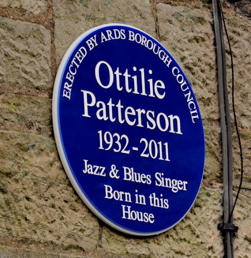
A recently-erected plaque, in memory of Ottilie Patterson Link and Link , at Carnesure Terrace, on the Old Ballygowan Road (close to here J4568 : Former Andrews Mill, Comber). Two links to...
- singer
- people
- events
- geograph
- city
- town centre
- blue plaque
- comber
"Kingsway" plaque, Dunmurry

The renaming plaque at Kingsway (last seen in March 2007 J2968 : Plaque). My understanding is that the street was previously known as either the Broad Road or the Main Road. © Copyright...
- people
- events
- street name sign
- geograph
- dunmurry
- suburb
- urban fringe
- roads
- road transport
Stone plaque, Pont Islwyn north of Ynysddu
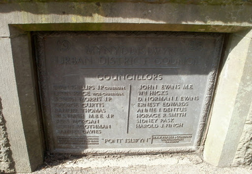
The Mynyddislwyn Urban District Council plaque is embedded in masonry on the west side of Pont Islwyn Link across the River Sirhowy. It records the opening of the bridge in 1928. ©...
- bridge
- geograph
- roads
- road transport
- stone plaque
Plaque marking the site of a demolished toll house, Usk

The Usk Civic Society plaque on a wall alongside Porthycarne Street records that this was the site of the Porthycarne Gate, a toll house demolished in 1880. © Copyright Jaggery and licensed...
- historic sit...
- geograph
Stewart Parker (playwright) plaque, Belfast

A plaque, on a house on the Larkfield Road J3775 : The Larkfield Road, Belfast, commemorating the playwright Stewart Parker Link and Link. © Copyright Albert Bridge and licensed for reuse under...
- belfast
- people
- events
- geograph
- suburb
- urban fringe
- blue plaque
Plaque recording the site of Nine Mile Point Colliery Workmen's Institute, Cwmfelinfach
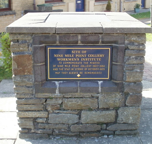
The plaque is in the residential cul-de-sac Nine Mile Point Court. Link © Copyright Jaggery and licensed for reuse under this Creative Commons Licence . Submitted via Geograph
- village
- rural settlement
- geograph
Datum Point

This plaque in the tower of Great St. Mary's church Cambridge marks the datum point for distances from Cambridge. For overall view see Link © Copyright Keith Evans and licensed for reuse under...
- datum point
- historic sit...
- geograph
"Goose Lane" plaque, Belfast

See J3374 : Plaque, Belfast. Another similar plaque nearby. This one recalls a time, more than 300 years ago, when Lower North Street was Goose Lane within the town walls, when geese were driven...
- people
- events
- city
- town centre
- belfast
- geograph
"9/11" plaque, Belfast

A plaque, at a tree in the City hall grounds, reading This tree was planted by Belfast City Council on 11th September 2002 to commemorate all those who so tragically lost their lives in...
- belfast
- people
- events
- geograph
- memorial plaque
- city
- town centre
Dungannon & South Tyrone Plaque

The following text is included, "Dungannon & South Tyrone Borough Council acknowledge the support of the Dickson Family in Providing Dickson Park as a public space." Pictured here H7962 : Arch,...
- park and pub...
- geograph
Plaque at Devil's Point

© Copyright David Smith and licensed for reuse under this Creative Commons Licence . Submitted via Geograph
- geograph
- historic sit...
- charles darwin
Military Service Plaque

The following text is included, "In recognition of the many men and women from Milltown who served their country in the Great War, WW II and other conflicts throughout the world . In...
- park and pub...
- geograph
Dungannon Swifts Football Club Plaque

The following text is included, "In the early years 'Swifts' used the playing fields near Milltown until Strangmore Park became their permanent home in 1975. Dungannon United Youth now have...
- park and pub...
- geograph
Telephone Exchange Plaque

The following text is included, "Government Building Telephone Exchange at Washingford Row, Milltown was built in 1956 by Boyd Bros Building Contractors of Newmills. It was the main...
- park and pub...
- geograph
Barracks, Stables & Forge Plaque
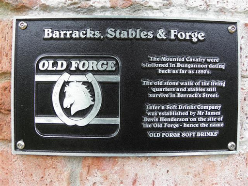
The following text is included, "The Mounted Cavalry were stationed in Dungannon dating back as 1850's. The old stone walls of the living quarters and stables still survive in Barrack Street....
- park and pub...
- geograph
European Union Plaque

The following text is included, "This project has been funded by EU's programme for Peace and Reconciliation (PEACE III) managed by the special EU Programme's Body in Partnership with Dungannon &...
- park and pub...
- geograph