
Blue plaque on the first shop of the Ripponden Co- operative Society

This co-operative society was one of the first in the country, founded in 1832. © Copyright Humphrey Bolton and licensed for reuse under this Creative Commons Licence . Submitted via Geograph
- lowlands
- geograph
- suburb
- urban fringe
- blue plaque
- business
- retail
- services
Lytham Railway Station Plaque

The plaque by the entrance to the Station Tavern SD3627 : Station Tavern is almost covered by ivy. It reads: LYTHAM ST ANNES CIVIC SOCIETY LYTHAM RAILWAY STATION Built in 1874 when the Blackpool...
- 1986
- lytham st an...
- railways
- geograph
- 1874
- historic sit...
- blue plaque
- ivy
- preston and wyre
Some aspects of Blandford's architecture: 38 Salisbury Street (detail 1)

The tablet commemorating the sculptor Alfred Stevens on the front of the building. Link © Copyright Mike Searle and licensed for reuse under this Creative Commons Licence . Submitted via Geograph
- housing
- dwellings
- people
- events
- house
- geograph
- city
- town centre
- historic sit...
Stockport Dungeon and Court Leet

The blue plaque erected by Northern Counties Housing Association and The Metropolitan Borough of Stockport on Mealhouse Brow SJ8990 : 8 Market Place and 1a Mealhouse Brow reads: STOCKPORT DUNGEON...
- northern cou...
- 1824
- geograph
- court leet
- historic sit...
- dungeons
- stockport mbc
Blatchington Court School plaque

The plaque is on the wall of the former chapel which is the last part remaining of the former school for partially sighted pupils which closed in 1985 © Copyright Paul Gillett and licensed...
- educational sites
- seaford
- school (former)
- geograph
Plaque on Aldeby Village sign

On Rectory Road © Copyright Adrian Cable and licensed for reuse under this Creative Commons Licence . Submitted via Geograph
- village
- rural settlement
- rectory road
- village sign
- geograph
- sign
- closeup
- aldeby
- aldeby village sign
Bradford City Water Works plaque On Pits Lane

Hartshead Moor Top. © Copyright Ian S and licensed for reuse under this Creative Commons Licence . Submitted via Geograph
- water resources
- geograph
John Knox Street -The Site of "The Debate"
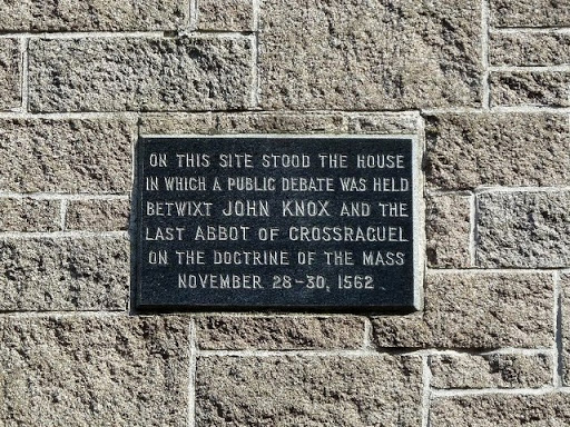
In John Knox Street, theres a plaque on the wall of a modern building which is close to the site of The Debate between Quintin Kennedy, Abbot of Crossraguel, and the famous Scottish...
- religious sites
- city
- town centre
- historic sit...
- geograph
Broomhill Bridge

Plaque on the south-eastern bridge pillar. The River Spey is just visible, to the left of picture. © Copyright Peter Trimming and licensed for reuse under this Creative Commons Licence . Submitted...
- lowlands
- bridge
- river spey
- scotland
- geograph
- rivers
- streams
- drainage
- highland
Plaque commemorating Emlyn Williams in Rhydymain

Emlyn Williams wrote and directed the Last Days of Dolwyn in 1949 and it says on the plaque this was filmed in Rhydymain. This tale of an English water company flooding a Welsh village for a...
- educational sites
- geograph
The arms of the Oddfellows, King Street

See NZ9504 : Explanatory notice on the Men's Institute for an explanation of the coat of arms. © Copyright Humphrey Bolton and licensed for reuse under this Creative Commons Licence ....
- geograph
- historic sit...
- coastal
- coat of arms
The eastern end of the Coast to Coast Walk

This is on the Bay Hotel. You have to walk a few more metres to reach the sea, except at high tide. © Copyright Humphrey Bolton and licensed for reuse under this Creative Commons Licence ....
- paths
- geograph
- city
- town centre
- coast to coast walk
- coastal
Plaque giving inscription on adjacent stone, Albion Street

See NZ9504 : Inscribed stone off Albion Street for the stone. © Copyright Humphrey Bolton and licensed for reuse under this Creative Commons Licence . Submitted via Geograph
- paths
- suburb
- urban fringe
- geograph
- historic sit...
- coastal
The plaque on the Naughty Stone

See SO0914 : 'The Naughty Stone' at Trefil Viewpoint for context. © Copyright Rod Allday and licensed for reuse under this Creative Commons Licence . Submitted via Geograph
- uplands
- sport
- leisure
- moorland
- geograph
County Boundary Plaque

Seen on the more modern of the two bridges, just south of Grantown-on-Spey. © Copyright Peter Trimming and licensed for reuse under this Creative Commons Licence . Submitted via Geograph
- bridge
- roads
- road transport
- geograph
Bangor: clock tower plaque

The plaque, on the side of the SH5872 : Bangor: the clock tower, explains that it was: "Erected and presented to the city of Bangor by Alderman Thomas Lewis, JP, Garth'erwen, during his mayoralty,...
- city
- town centre
- clock tower
- geograph
Plaque in Lundy Church

This plaque in St Helena's church porch is self- explanatory. The eight bells were originally installed in 1897 but had to be removed from the tower in the 1950s for safety reasons. ©...
- religious sites
- bellringers
- geograph
- church porch
Memorial plaque, Pen-y-ghent

On top of the outcrop SD8373 : Gritstone outcrop, Pen-y-ghent. The inscription reads - Sgt. Aubrey Taylor Died 7.3.88 B. Coy. W.F.R. Notts. ACF Rest easy old friend Your work goes on Harworth...
- memorial plaque
- historic sit...
- geograph
Wall plaque in Wells Place

© Copyright Basher Eyre and licensed for reuse under this Creative Commons Licence . Submitted via Geograph
- people
- events
- city
- town centre
- historic sit...
- geograph
Plaque on Hawkhead Bridge

The bridge takes Hawkhead Road over the White Cart Water. For a close-up view of the plaque, see NS5062 : Plaque on Hawkhead Bridge. The present picture shows it in context, as does an...
- bridge
- road bridge
- historic sit...
- geograph