Swamps on the Cusp of Change
Cypress-tupelo swamps along the Louisiana coast are subjected to a number of environmental stressors, ranging from hurricane impact to saltwater intrusion. Some of these impacts are created by the pressures of development, while others are natural. Environmental change will have consequences for cypress-tupelo swamps. Greater incidences of drought, storm surge, and saltwater intrusion couple with the persistent effects of sea-level rise and coastal land submergence to provide serious natural threats to these habitats. Land submergence is especially evident in Bayou Teche National Wildlife Refuge.
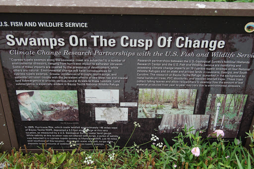
Research partnerships between the U.S. Geological Survey's National Wetlands Research Center and the U.S. Fish and Wildlife Service are monitoring and assessing climate change impacts on 16 cypress-tupelo swamps on four National Wildlife Refuges and on state and private lands in Louisiana, Georgia, and South Carolina. The research at Bayou Teche Refuge is marked in the background by metal bands on trees, PVC structures, and wooden litterfall traps. These traps collect falling leaves and allow researchers to examine how the amount of eaf material produced from year to year may vary due to environmental stressors.
In 2005, Hurricane Rita, which made landfall approximately 140 miles west of Bayou Teche NWR, deposited a 5.3 foot storm surge at this very location, as measured by a U.S. Geological Survey water gauge. While salinity at this location was not altered with surge, a pulse of salinity was detected in a cypress-tupelo swamp at Mandalay NWR, just 40 miles east-southeast of this location. Along with water and salt, surge often deposits large amounts of sediment in cypress-tupelo swamps.