Northern Boundary of Rancho San Antonio
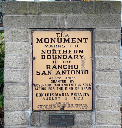
There's an earlier Read the Plaque entry that shows the reverse side of this marker, on San Pablo Avenue, right in front of the Wells Fargo Bank branch next to El Cerrito Plaza. To be honest, I hadn't noticed the two sides were different until I was walking by the marker this past weeks; I've been driving by it for decades. Anyway, here's the text:
This Monument
Marks the
Northern Boundary
of the
Rancho
San Antonio
Granted by
Governor Pablo Vicente de Sola
Acting for the King of Spain
to
Don Luis Maria Peralta
August 3, 1820
Erected by Oakland Junior Chamber of Commerce and
Explorers, Troop 26, Boy Scouts of America
Ferro Porcelain. A.D. 1937
The small brass tablet below apparently marks a sprucing up of the monument: "Dedicated by Soroptimist International of El Cerrito, June 1977."
The area of this grant covered everything from Cerrito Creek on the north to San Leandro Creek on the south, from the bay shore to the crest of the hills
Submitted by @danbrekke