
Dame Laura Knight plaque, Colwall

At the entrance doorway to Colwall Park, behind the open white door here. Link The Colwall Village Society plaque records that the painter's studio was in Colwall Park from 1947-1961. During...
- village
- rural settlement
- people
- events
- historic sit...
- geograph
The Winnings fence and plaque, Colwall

This is one of two entrances to The Winnings from the B4218 Walwyn Road. Link to a closer view of the plaque. © Copyright Jaggery and licensed for reuse under this Creative Commons Licence...
- village
- rural settlement
- historic sit...
- fence
- geograph
Stephen Ballard plaque, The Winnings, Colwall

Located here. Link The Colwall Village Society plaque records that Stephen Ballard 1804-1890, engineer, entrepreneur, contractor, conservationist, lived at The Winnings for many years. © Copyright...
- village
- rural settlement
- historic sit...
- geograph
Circular brass plaque, Omagh

Embedded in the footpath here H4572 : Footpath along Market Street, Omagh © Copyright Kenneth Allen and licensed for reuse under this Creative Commons Licence . Submitted via Geograph
- roads
- road transport
- geograph
South City Market / Georges Street Arcade

A plaque on South Great George's Street, Dublin. © Copyright Ian S and licensed for reuse under this Creative Commons Licence . Submitted via Geograph
- geograph
- city
- town centre
- market
- market hall
- business
- retail
- services
Dix ans d'amitié (ten years of friendship), Lèves et Nailsworth

The plaque located between the public library and the Mortimer Room Link records the tenth anniversary in 2005 of the 1995 twinning of Nailsworth and Lèves in France. © Copyright Jaggery and...
- city
- town centre
- twinning plaque
- geograph
Plaque on the former All Saints Mission Room

On Forncett Street, just down the hill from the site of All Saints Church which was demolished in the nineteen seventies. Most of the humble houses that once stood in this area were demolished...
- religious sites
- industry
- geograph
Plaque in Belsize Park tube station

See TQ2785 : The entrance to Belsize Park tube station. © Copyright Mike Quinn and licensed for reuse under this Creative Commons Licence . Submitted via Geograph
- underground station
- city
- town centre
- railways
- geograph
Wren House - blue plaque

On Wren House, Vicarage Street - once a Georgian clothier's house, now a residential care home ST8645 : Wren House, Warminster. © Copyright M J Richardson and licensed for reuse under...
- lowlands
- village
- rural settlement
- wiltshire
- warminster
- 18th century house
- geograph
- health and s...
- wren house
- historic sit...
- blue plaque
Warminster Maltings plaque

A 'blue plaque' on the wall of the maltings on Pound Street. © Copyright M J Richardson and licensed for reuse under this Creative Commons Licence . Submitted via Geograph
- lowlands
- village
- rural settlement
- wiltshire
- industry
- warminster
- maltings
- geograph
- historic sit...
- blue plaque
The Traditional Cornmillers Guild - plaque at Whissendine windmill

Screwed to the inside of the door into the tower mill. This is a commercially working mill but the owner will usually let you have a look if you ask him. © Copyright Chris Allen and licensed...
- windmill
- industry
- geograph
- historic sit...
- tower style mill
- whissendine
Great Market House information board, Tetbury

© Copyright Jo Turner and licensed for reuse under this Creative Commons Licence . Submitted via Geograph
- city
- town centre
- geograph
Plaque at the Izaak Walton Gauging Station

The plaque states: This weir was constructed by the Trent River Authority in 1969. Its purpose is to measure continually the flow of water in the River Dove. © Copyright Mat Fascione and...
- geograph
- river
- rivers
- streams
- drainage
- gauging station
Glamorgan Heritage Coast logo, Cwm y Befos

Attached to the left hand post of the stile seen in SS8577 : Stile and gate, Cwm y Befos. There do not appear to be any other of these Glamorgan Heritage Coast plaques in the area, so maybe...
- paths
- tythegston
- waymark
- geograph
- cwm y befos
- waymarker
- signage
- logo
Blue Plaque

Blue plaque on Bethesda'r Fro Chapel. © Copyright Alan Hughes and licensed for reuse under this Creative Commons Licence . Submitted via Geograph
- religious sites
- geograph
Plaque at the Tree of Life at The Hayes Conference Centre

This photo shows a plaque at the base of the Tree of Life with the following wording: This tree was planted during the World Mission Conference. Attended by people from many parts of the world...
- commemorative plaque
- suburb
- urban fringe
- geograph
National Care Homes Association plaque, Culver Street, Newent

On the wall here. Link © Copyright Jaggery and licensed for reuse under this Creative Commons Licence . Submitted via Geograph
- geograph
- business
- retail
- services
- housing
- dwellings
- suburb
- urban fringe
Information plaque, Picnic Area, Gorse Lane, Tog Hill, Wick

© Copyright Jo Turner and licensed for reuse under this Creative Commons Licence . Submitted via Geograph
- historic sit...
- geograph
Campaign to Protect Rural England plaque, Nailsworth

The green plaque is on a side wall near this Link restored Victorian fountain. © Copyright Jaggery and licensed for reuse under this Creative Commons Licence . Submitted via Geograph
- city
- town centre
- historic sit...
- campaign to ...
- geograph
Gwilym Williams plaque, Cardiff
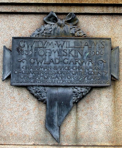
Located here. Link © Copyright Jaggery and licensed for reuse under this Creative Commons Licence . Submitted via Geograph
- city
- town centre
- public build...
- historic sit...
- geograph