
Point Peter Battery and the War of 1812

In 1795 a cannon battery constructed on the Point Peter peninsula became the southernmost fortification in the First System of U.S. coastal defenses. Vacated in 1802, it was reoccupied...
- lat34
Treaty of Coleraine

On June 29, 1796, this Treaty was signed ¼ mile south of here near Indian Agent James Seagrove´s home, a trading post and garrison of Federal troops on the St. Marys River. The meeting included...
- lat34
Camden County

Formed from old Colonial parishes: St. Mary and St Thomas. Camden one of eight original counties of Georgia created by the State Constitution of 1777. County named for Charles Pratt, Earl of...
- lat34
Point Peter

East of here, at the junction of Peter Creek and the St. Marys river, the British built Fort Tonyn in 1776; controlling the southern part of the colony of Georgia for two years. In 1778,...
- lat34
Refuge Plantation

On the Satilla River 2.8 miles from here, was one of the largest rice plantations in the South. Originally a crown grant of 500 acres to George McIntosh in 1765. It p[assed to his son,...
- lat34
First Pecan Trees Grown Here About 1840

Grown from pecan nuts found floating at sea by Captain Samuel F. Flood and planted by his wife, nee Rebecca Grovenstine on Block 47. The remainder of these nuts were planted by St. JOseph...
- lat34
Washington Pump & Oak

There were originally six wells one in each square, the only source of pure water for St. Marys, (until the tidal wave of 1818). On the day that the Father of the Country was buried at Mt. Vernon...
- lat34
Tabby Sugar Works of John Houstoun McIntosh

These are the ruins of a tabby sugar works built by John Houston McIntosh at New Canaan PLantation soon after 1825. In hiss sugar house McIntosh installed what was, according to Thomas...
- lat34
St. Marys Methodist Church Established 1799-1800

This church is the oldest religious organization in the city, although not the oldest church building. George Clark served as the first missionary to the people here in 1792. John Garvin was the...
- lat34
City of St. Marys

The town was built on the north bank of the St. Marys River at a place called Buttermilk Bluff. The original tract of land, containing 1620 acres, was purchased by the proprietors for laying...
- lat34
First Presbyterian Church

Built by public subscription as a place of divine worship for inhabitants of St. Marys and its vocinity. Reverend Horace Southworth Pratt was ordained and installed as the first pastor by...
- lat34
Hernando DeSoto In Georgia

Hernando de Soto, born ca. 1500, nobleman, conquistador, governor of Cuba, with rights to conquer Florida, traveled in 1540 through what later became Georgia on an expedition to find gold. His...
- lat34
Calhoun County

This county, created by Act of the Legislature Feb. 20, 1854, is named for John C. Calhoun, famed South Carolina Statesman, who resigned as Vice President of the United States in 1832 to return to...
- lat34
Blue Star Memorial Highway

A tribute to the Armed Forces that have defended the United States of America SPONSORED BY Butts County Garden Club Council IN COOPERATION WITH Redbud District Of The Garden Clubs of Georgia, Inc...
- lat34
Home of Robert Grier

Robert Grier, astronomer and founder of "Grier´s Almanac", and his family lived about one mile from here and are buried in a family cemetery near the home. Robert Grier was born in 1780 at...
- lat34
Kilpatrick at Cork

On Nov. 17, 1864, Kilpatrick´s cavalry division which was covering the right flank of Gen. Sherman´s army on its March to the Sea, moved from Bear Creek Station (Hampton), 30 mi. NW, down...
- lat34
Sherman's Right at Indian Springs
![On Nov. 17, 1864, the 15th Corps, leading the Right Wing of Gen. Sherman´s army [Union] on its March to the Sea, marched through McDonough to Jackson. Below Locust Grove (16 mi. NW), Woods´ and...](http://lh3.googleusercontent.com/XcbZppAPpVr77RfW00bCKoHRTQlqxfXPic_XiFOnuEIe0V5e4SDnw6QZCtAphvMACZx84mtobk-Br1Kj30gzonM5m8vU)
On Nov. 17, 1864, the 15th Corps, leading the Right Wing of Gen. Sherman´s army [Union] on its March to the Sea, marched through McDonough to Jackson. Below Locust Grove (16 mi. NW), Woods´ and...
- lat34
The March to the Sea

On Nov. 17th, the Right Wing of Gen. Sherman´s army (U) marched from McDonough to Jackson, enroute to Planter´s Factory on Ocmulgee River where it was to cross next day. To relieve congestion on...
- lat34
Iron Springs
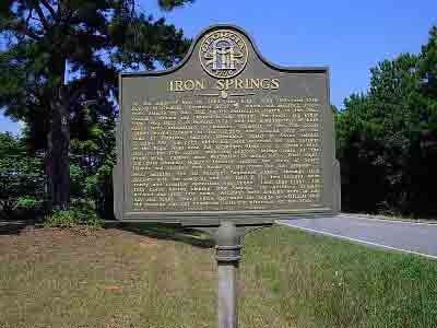
On the night of Nov. 17, 1864, the Right Wing (15th and 17th Corps) of General Sherman´s army, which had marched south from Atlanta on Nov 15th on its destructive March to the sea, reached Jackson...
- lat34
Crossing the Ocmulgee
![On the night of Nov. 17, 1864, the Right Wing (15th and 17th Corps) of General Sherman´s army [Union], which had marched south from On the morning of Nov. 18, 1864, the Right Wing (15th and 17th...](http://lh3.googleusercontent.com/y2aFtdrurhtiemv6scNGNFNkRfLSDY--bM0L5JiMv73wwJukECwk6PDP1aHHYHChaF6gdXREPAC8AuQ7inB_uSSM4trypA)
On the night of Nov. 17, 1864, the Right Wing (15th and 17th Corps) of General Sherman´s army [Union], which had marched south from On the morning of Nov. 18, 1864, the Right Wing (15th and 17th...
- lat34