
Pulaski Bridge
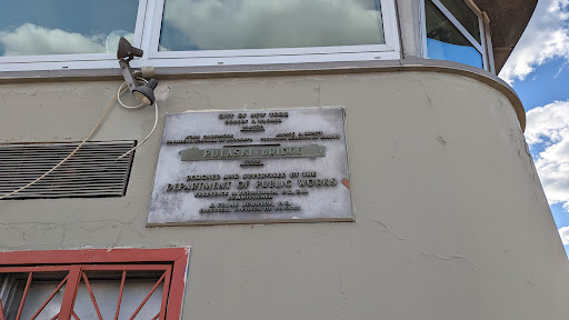
CITY OF NEW YORK ROBERT F. WAGNER MAYOR JOHN CASHMORE PRESIDENT, BOROUGH OF BROOKLYN JAMES A. LUNDY PRESIDENT, BOROUGH OF QUEENS PULASKI BRIDGE 1954 DESIGNED AND SUPERVISED BY THE DEPARTMENT...
- new york
- brooklyn
- queens
- greenpoint
- long island city
- bridge
- robert wagner
- john cashmore
- james lundy
Gloria & Don LeVine

In loving memory. Gloria & Don LeVine Married 1946: Partners, Parents, Grandparents "Those were the days..."Submitted by @lampbane
- new york
- brooklyn
- prospect park
- bench
General William Booth

TO THE GLORY OF GOD UNDER THE DIRECTION OF GENERAL WILLIAM BOOTH THE FOUNDER OF THE SALVATION ARMY COMMISSIONER GEORGE S. RAILTON AND SEVEN WOMEN OFFICERS UNFURLED THE FLAG OF THE SALVATION...
- new york
- manhattan
- battery park
- the battery
- william booth
- salvation army
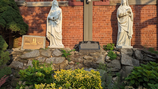
Riverview Homes Association

RIVERVIEW HOMES ASSOCIATION Incorporated 1 May, 1923 One of the earliest examples of not-for- profit housing cooperatives in the United States, Riverview Homes was established and constructed...
- new york
- brooklyn
- sunset park
- finland
- finntown
- 1923
Kiusala
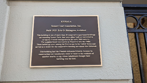
KIUSALA Sunset Court Association, Inc. Built 1925 Eric O. Holmgren, Architect This building is one of more than 30 cooperative apartment buildings surrounding Sunset Park, that were either...
- new york
- brooklyn
- sunset park
- finland
- finntown
- 1925
Point Emery
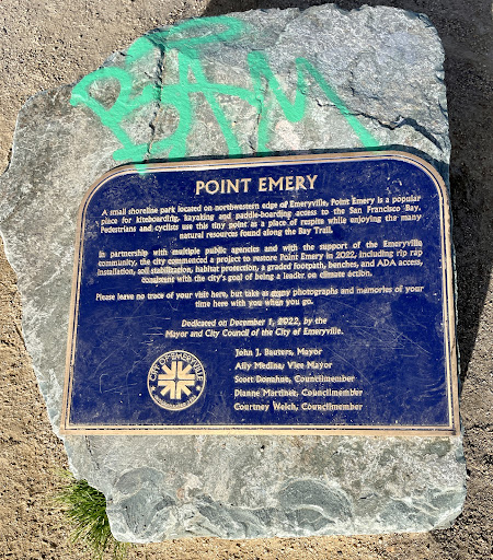
POINT EMERY A small shoreline park located on northwestern edge of Emeryville, Point Emery is a popular place for kiteboarding, kayaking and paddle-boarding access to the San Francisco...
In Vicinity of French Trading Area

In the mid-1700s, Indians of the region met at a trading ground near this site with Frenchmen who brought them manufactured goods, sometimes including guns and ammunition — products denied them by...
- texas
- native americans
- colonial history
Archer County Copper Mines

(1/4 mile northeast and 5 miles to the south southeast) The civilized world first heard of copper in this area from Texas Rangers after an 1860 campaign against Comanches on the Pease River,...
- texas
- archer county
- mining
- civil war
Dad's Corner

The result of a 1923 oil boom, development of a town at this site included some twenty-two businesses, including a food stand operated by a man with the nickname “Dad,” which provided a name for...
- texas
- oil
- boomtowns
- ghost towns
Camp Stonewall Jackson

Area Confederate veterans officially formed the Stonewall Jackson Camp #249, United Confederate Veterans, in 1897. The group purchased 106 acres located south of Holliday, along Holliday Creek, as...
- texas
- archer county
- civil war
- confederate veterans
The Old Buffalo Road

(About 100 yards to the west) Named for its traffic in buffalo hides and bones, this North Texas road gave subsistence to pioneers while aiding in mass “harvest” of the American bison. As long...
- texas
- native americans
- buffalo
- bison
A Jesse James Hideout

(Located 2 blocks west and 2 blocks north) Jesse James, celebrated 1860s-82 Missouri outlaw, used to visit in Archer City in house built by Stone Land & Cattle Company for its manager, Allen...
- texas
- archer county
- archer city
- jesse james
- frank james
- outlaws
Archer County Discovery Well

(Approximately 13 mi. SE) M.P. Andrews No. 1, drilled in 1911, reached oil sands at 920 feet. Well first flowed oil, March 1912, at rate of 10 barrels a day. Production in this shallow...
- texas
- archer county
- archer city
- oil
- petroleum
Extinct Town of Anarene

Landowner Charles E. Graham (1872-1937) in 1908 granted the Wichita Falls and Southern Railroad a route across his property and platted a town at this site. Anarene was named for his wife...
- texas
- archer county
- anarene
- ghost towns
- last picture show
The Battle of Palo Duro Canyon

September 28, 1874 One of the most significant battles of 1874-75 Indian campaign; columns of troops converging from five directions harassed Indians on the Panhandle Plains for over six months. ...
- palo duro canyon
- ranald mackenzie
- comanches
- kiowas
- native amiercans
The S.P. Hamblen Family

Pioneered at this site, in dugout to the west. S.P. Hamblen (1846-1930) and wife Virginia (1861-1950) settled in Lakeview area (9 mi. S of Claude) in 1889. Hamblen helped establish...
- texas
- s.p. hamblen family
- prairie dog ...
William E. Schott

Briscoe County pioneer William E. Schott (1870-1941) was born in Ohio and moved to North Texas in 1885. Still legally a minor, he came to this area in 1890 and filed a claim for the first of his...
- texas
- briscoe county
- palo duro canyon
- william e. schott
Hamblen Drive

Named for William H. Hamblen (1878-1952), who in 1890s pioneered a crude road (about 6 mi. N) into Palo Duro Canyon along old Indian trails. This cut 120 miles off settlers' trips to the...
- texas
- brisco county
- palo duro canyon
- hamblen
- highways
Weatherford, Mineral Wells and Northwestern Railway

In 1852, years before the nations’s first transcontinental rail line was completed in 1869, the Texas Legislature chartered what would become the Texas & Pacific Railway Company. The Civil...
- texas
- palo pinto county
- parker county
- mineral wells
- railroads
- resorts
The Old JA Ranch

n 1876, veteran Texas cattleman Charles Goodnight entered Palo Duro Canyon by way of an old Comanche Indian trail near here, to establish the first ranch in this area.In 1877, Goodnight...
- texas
- palo duro canyon
- charles goodnight
- cattle
- ranching