

Former Florida Manor Courthouse (2)
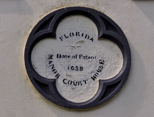
See J4662 : Former Florida Manor Courthouse (1). The plaque which refers to Date of patent 1638. It refers, I think, to the granting of Letters Patent giving the right to establish a court...
- village
- rural settlement
- court house (former)
- geograph
Blue plaque, Bridge House

"William Wynne Westcott, (1848-1925) lived here, surgeon, supreme Magus for the Societas Rosicruciana in Anglia, founder of the Hermetic Order of the Golden Dawn, Master of the Occult, Freemason...
- fruitloopery
- housing
- dwellings
- geograph
Centenary plaque, Llandeilo Bridge

The stone plaque on the bridge Link was placed here in 1948 to commemorate the centenary of the bridge's opening. The plaque depicts the 7-arch medieval bridge that formerly spanned the River Towy...
- geograph
- rivers
- streams
- drainage
- suburb
- urban fringe
- stone plaque
- roads
- road transport
Memorial plaque, Greencastle
It is located here C6440 : Memorial, Greencastle © Copyright Kenneth Allen and licensed for reuse under this Creative Commons Licence . Submitted via Geograph
- park and pub...
- geograph
Inscribed plaque, William Yeaman

It is located here D0345 : Lime Kiln at Ballintoy This is him in action, an early picture of mine, overlooking the North Antrim Coast D0143 : Artist at work © Copyright Kenneth Allen and licensed...
- public build...
- geograph
Ards TT plaque, Dundonald

The Ards TT was a motor race over 13½ miles of public roads. The course started here, on the Upper Newtownards Road, Dundonald and ran via Newtownards (over Bradshaws Brae) and Comber. The first...
- ards tt
- motor racing circuit
- geograph
- sport
- leisure
- dundonald (co down)
- suburb
- urban fringe
- motor sport
- roads
- road transport
Commemorative plaque by Cheddleton Top Lock, Staffordshire

By the side of Lock No 13 on the Caldon Canal, the plaque states: THE CALDON CANAL WAS RE-OPENED TO NAVIGATION ON 28TH SEPTEMBER 1974 BY MRS. G. OXFORD ON BEHALF OF STAFFORDSHIRE COUNTY...
- canals
- geograph
Plaque on the Bunhill Fields Meeting House (Society of Friends), off Banner Street, EC1

See TQ3282 : Bunhill Fields Meeting House (Society of Friends), off Banner Street, EC1. © Copyright Mike Quinn and licensed for reuse under this Creative Commons Licence . Submitted via Geograph
- religious sites
- city
- town centre
- geograph
Plaque, Toll House

The plaque is on the toll house. For a view of the building NN8621 : Toll House, Crieff © Copyright Maigheach-gheal and licensed for reuse under this Creative Commons Licence . Submitted via Geograph
- housing
- dwellings
- geograph
- roads
- road transport
- suburb
- urban fringe
- toll house
The Spirit of Heysham
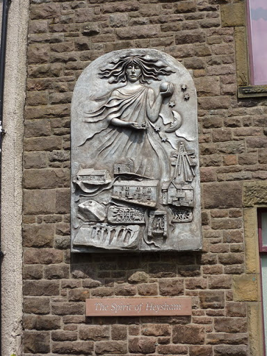
To be found on the wall of the Institute on Main Street © Copyright Alexander P Kapp and licensed for reuse under this Creative Commons Licence . Submitted via Geograph
- public build...
- geograph
Plaque, St Peter's Church

This plaque is above the main door to the church. For a view of it in situ SU1156 : Door, St Peter's Church © Copyright Maigheach-gheal and licensed for reuse under this Creative Commons Licence...
- village
- rural settlement
- religious sites
- geograph
Plaque, The Colthurst Hall, Richhill

It is located here H9448 : Colthurst Hall, Richhill © Copyright Kenneth Allen and licensed for reuse under this Creative Commons Licence . Submitted via Geograph
- public build...
- geograph
Plaque, Ensor Masonic Hall

It is located here H9052 : Ensor Masonic Hall, Loughgall © Copyright Kenneth Allen and licensed for reuse under this Creative Commons Licence . Submitted via Geograph
- public build...
- geograph
Ian Kennedy plaque, Helen's Bay

Self-explanatory plaque in this wood J4581 : Woodland near Helen's Bay (1). © Copyright Albert Bridge and licensed for reuse under this Creative Commons Licence . Submitted via Geograph
- paths
- woodland
- forest
- people
- events
- woodland
- geograph
- suburb
- urban fringe
- helens bay
- clandeboye avenue
The Museum of British Resistance Organisation (BRO) - plaque

For a wider view of this location see > Link. The Museum - it is situated in Nissen Huts adjoining the 390th Bombardment Group Memorial Air Museum Control tower at Parham Airfield > Link - houses...
- educational sites
- defence
- military
- museum
- geograph
Blue plaque at Edgeley Park, Stockport
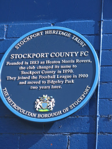
The blue plaque at Edgeley Park, Stockport. This is on the road side of the Hardcastle main stand, adjacent to the Players and officials entrance. © Copyright Dave Pickersgill and licensed for...
- edgeley park
- geograph
- sport
- leisure
- historic sit...
- stockport
Plaque on the Guildhall

Mounted high above the front portico of the Guildhall, this stone plaque records the gift of the building by the second Earl of Radnor to the city of Salisbury in 1794 for the "Use of the Mayor...
- guildhall
- public build...
- geograph
- inscribed plaque
- city
- town centre
- historic sit...
- stone plaque
Plaque, Cloughaneely Club Hall

It reads, "Arus Chloich Cheann Fhaola, - tógadh 1910, agus ath-uair (iar a loisgeadh* ag Gallaibh) 1923" The English translation is "Cloughaneely Club - built 1910, and rebuilt (after it...
- public build...
- geograph
Plaque marking site of Queen Elizabeth Grammar School for Boys, Carmarthen
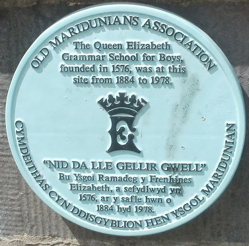
The Old Maridunians Association plaque is at the entrance Link to Parc Myrddin. © Copyright Jaggery and licensed for reuse under this Creative Commons Licence . Submitted via Geograph
- historic sit...
- geograph
Plaque on the bridge

This plaque is attached to SU1430 : Scamell's Bridge, a former railway bridge that now carries Nelson Road over the River Avon. Note how the line spacing varies, getting wider towards the...
- old bridge
- iron bridge
- railways
- geograph
- railway bridge
- suburb
- urban fringe
- roads
- road transport
- rivers
- streams
- drainage