

The Fishing Boat sculpture (3) - plaque, Harbour Road, Portstewart
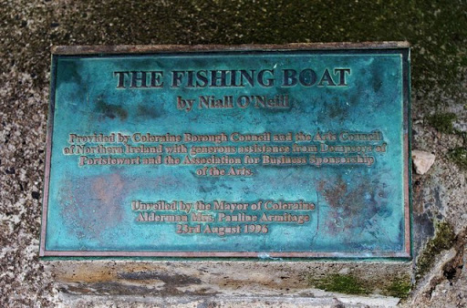
One of the two plaques at the foot of the sculpture. See also:- C8138 : The Fishing Boat sculpture (1), Harbour Road, Portstewart. © Copyright P L Chadwick and licensed for reuse under this...
- city
- town centre
- sculpture
- geograph
The Ropley Race Stones

This stone, actually a piece of concrete, lies on the edge of the recreation ground. The plaque reads:- THE ROPLEY RACE STONES Extract from "Annals of Old Ropley" by Marianne Hagen 1929 "A dispute...
- lowlands
- village
- rural settlement
- geograph
- closeup
- historic sit...
Plaque on Millennium Stone

Plaque on Millennium Stone in Treeleck Grange. See: SO4901 : Millennium standing stone, Trelleck Grange © Copyright Philip Halling and licensed for reuse under this Creative Commons Licence...
- historic sit...
- geograph
Willowbrook Road bridge - date plaque
![The plaque is on the north spandrel of the bridge TQ3377 : Willowbrook Road bridge. It reads: SCC [Surrey Canal Co.] Hill Street Bridge AD 1870. Presumaby Hill Street was the old name for...](http://lh3.googleusercontent.com/ZUArMiPO3OvBScobuUfA_BDye0e3Z_tRCAx3WDPccGhfMxlxg-qyj6roDLCCy8x6N7tPt0qVwzNu-9rg-utKQ9fdds9rJA)
The plaque is on the north spandrel of the bridge TQ3377 : Willowbrook Road bridge. It reads: SCC [Surrey Canal Co.] Hill Street Bridge AD 1870. Presumaby Hill Street was the old name...
- geograph
- roads
- road transport
- 1870
- surrey canal
Plaque, Bolton Church

A plaque on the outer side of the kirkyard wall referring to members of Robert Burns' family that are buried here. © Copyright Richard Webb and licensed for reuse under this Creative...
- religious sites
- historic sit...
- geograph
Plaque on the Battle of Roslin monument
The plaque marks the erection of the monument in 1994 by the Roslin Heritage Society - see Link for photographs from the opening ceremony. © Copyright Jim Barton and licensed for reuse under...
- historic sit...
- geograph
JW Carey plaque, Belfast

A plaque, at Knockdene Park, commemorating Joseph William Carey, painter Link . See also J2058 : Kilwarlin Moravian Church. © Copyright Albert Bridge and licensed for reuse under this...
- belfast
- people
- events
- geograph
- suburb
- urban fringe
- blue plaque
Plaque on porch of St. Joseph's Church, Kilclaren

The plaque says that "This chapel was erected by the Revd. A. Connellan P.P. A.D. 1863." The plaque is on the exterior wall of the porch. R5689 : St. Joseph's Church, Kilclaren. © Copyright P...
- village
- rural settlement
- religious sites
- geograph
Plaque on the bridge at Bridgnorth
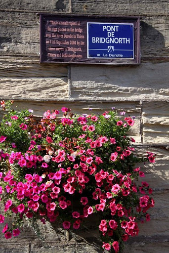
The sign is a replica of the one on the bridge over the River Durolle in Thiers, Bridgnorth's twin town. © Copyright Steve Daniels and licensed for reuse under this Creative Commons Licence...
- public build...
- geograph
Plaque on the shelter
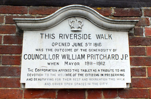
This plaque, fixed to the end of the SU1429 : Park shelter, commemorates the opening of the Riverside Walk on the 5th of June 1916. © Copyright Seo Mise and licensed for reuse under this Creative...
- paths
- park and pub...
- geograph
- footpath
- park shelter
Text, Tumbling Well

The biblical text that is inscribed on a marble tablet within the well shown in NZ2305 : Tumbling Well, Middleton Tyas © Copyright Maigheach-gheal and licensed for reuse under this Creative...
- village
- rural settlement
- middleton tyas
- well
- geograph
- water resources
Story on the post

A potted history of the Kennet and Avon canal can be found on the side of the information display board. © Copyright Bill Nicholls and licensed for reuse under this Creative Commons Licence...
- village
- rural settlement
- explanatory plaque
- educational sites
- information plaque
- geograph
- historic sit...
Plaque, Gort Gill Schools

The word "National" may be deleted It is located here J0091 : Gort Gill National Schools, Toome © Copyright Kenneth Allen and licensed for reuse under this Creative Commons Licence . Submitted via Geograph
- educational sites
- geograph
Plaque, The Creamery Burn

Pictured here D0501 : Entrance, The Creamery Burn Playarea © Copyright Kenneth Allen and licensed for reuse under this Creative Commons Licence . Submitted via Geograph
- park and pub...
- geograph
Village of the Year plaque, Ahoghill

Pictured here D0501 : The Wash Basin, Ahoghill © Copyright Kenneth Allen and licensed for reuse under this Creative Commons Licence . Submitted via Geograph
- village
- rural settlement
- geograph
Plaque, Fourtowns Primary School

Pictured here D0401 : Fourtowns Primary School, Ahoghill © Copyright Kenneth Allen and licensed for reuse under this Creative Commons Licence . Submitted via Geograph
- educational sites
- geograph
Plaque of former railway station site
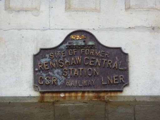
Renishaw Central Station , see also SK4478 : Chesterfield Canal, Bridge No. 18. © Copyright Peter Barr and licensed for reuse under this Creative Commons Licence . Submitted via Geograph
- name plaque
- railway stat...
- railways
- geograph
Plaque on bridge over the Spey, Aviemore

© Copyright Phil Champion and licensed for reuse under this Creative Commons Licence . Submitted via Geograph
- bridge
- river spey
- roads
- road transport
- geograph
Best kept village plaque

On Seagrave Green. The award for the Central Area was won in 2008. The sign seen here Link no longer exists. © Copyright Alan Murray-Rust and licensed for reuse under this Creative Commons Licence...
- lowlands
- village
- rural settlement
- best kept village
- park and pub...
- village green
- geograph
"Alec the goose" sculpture, Belfast (2)

See J3473 : "Alec the goose" sculpture, Belfast (1). The explanatory plaque and the print of a webbed foot. © Copyright Albert Bridge and licensed for reuse under this Creative Commons Licence ....
- belfast
- people
- events
- geograph
- city
- town centre
- gordon muir ...
- sculpture