
Plaque on lime kiln, Stone Quarry Road

Details of a plaque on the lime kiln shown in TA0093 : Lime kiln, Stone Quarry Road, Burniston. © Copyright Christopher Hall and licensed for reuse under this Creative Commons Licence . Submitted...
- village
- rural settlement
- lime kiln
- geograph
Plaque at Mary Stevens Park, Stourbridge

The plaque, attached to a small wall, reads:- "Mary Stevens Park. Helping to make Dudley a healthy borough". These days Stourbridge is part of the Metropolitan Borough of Dudley. Behind the wall...
- park and pub...
- geograph
- sport
- leisure
- suburb
- urban fringe
- public park
St John's Pend

Plaque in the archway at the entrance to St John Street. NT2673 : Entrance to St John Street from the High Street © Copyright M J Richardson and licensed for reuse under this Creative...
- lowlands
- edinburgh
- st john
- high street
- geograph
- city
- town centre
- historic sit...
St John's Cross plaque

In the archway where St John Street joins the High StreetNT2673 : Entrance to St John Street from the High Street, near to where the cross is set in the roadway NT2673 : St John's Cross on the...
- lowlands
- edinburgh
- st john
- boundary
- barrier
- cross
- geograph
- city
- town centre
- historic sit...
- high street
Old Playhouse Close
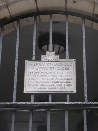
Plaque on the locked gate at the entrance to the close. © Copyright M J Richardson and licensed for reuse under this Creative Commons Licence . Submitted via Geograph
- lowlands
- edinburgh
- high street
- geograph
- city
- town centre
- historic sit...
- close
- playhouse
Trull: plaque on the gold postbox

A close-up of the plaque affixed to the side of ST2122 : Trull: postbox № TR3 246, Church Road. © Copyright Chris Downer and licensed for reuse under this Creative Commons Licence . Submitted via Geograph
- village
- rural settlement
- olympic gold postbox
- postbox
- olympic games 2012
- geograph
- communications
- business
- retail
- services
Gheluvelt Park - plaque in park, Barbourne, Worcester

Located near the main gate (memorial arch), this plaque reads:- "Gheluvelt Park. This park, formerly known as the Barbourne College Recreation Ground, was renamed by the Corporation in 1918...
- public park
- park and pub...
- suburb
- urban fringe
- geograph
Gheluvelt Park - plaque on main gate, Barbourne Road, Worcester

One of the two plaques on the main gate, or memorial archway. This one is on the right-hand side. It reads:- "City of Worcester Homes for Disabled Sailors and Soldiers. These homes were erected...
- park and pub...
- geograph
- suburb
- urban fringe
- war memorial
- gate
- memorial arch
Gheluvelt Park - plaque on main gate, Barbourne Road, Worcester

One of the two plaques on the main gate, or memorial archway. This one is on the left-hand side. It reads:- "City of Worcester. This park was opened on the 17th June 1922 by Field Marshall The Rt....
- park and pub...
- geograph
- suburb
- urban fringe
- war memorial
- gate
- memorial arch
Plaque on the former Friends School

Detail of a blue descriptive plaque on the former Friends School. The context of the building is shown in NZ5610 : High Green, Great Ayton © Copyright Christopher Hall and licensed for reuse under...
- village
- rural settlement
- geograph
Plaque on the Library

Detail of a plaque on the Library which was originally the British School. The context of the building is shown in NZ5610 : High Street, Great Ayton, looking east. © Copyright Christopher Hall and...
- village
- rural settlement
- geograph
Memorial Plaque, Southampton

Located on the city walls walk. The plaque commemorates the repatriation of Far East prisoners of war, and the vessels used to return them to Southampton. © Copyright Peter Trimming and licensed...
- southampton
- people
- events
- geograph
- hampshire
- city
- town centre
- historic sit...
QE2 Anchor Plaque, Southampton

Plaque, outlining the QE2 history. SU4211 : QE2 Anchor, Southampton © Copyright Peter Trimming and licensed for reuse under this Creative Commons Licence . Submitted via Geograph
- southampton
- city
- town centre
- hampshire
- geograph
Holyrood Church, Southampton
Holyrood Church (or Holy Rood Church) was one of the original five churches serving the old walled town of Southampton. Built in 1320, the church was destroyed by bombing, during the blitz, on...
- southampton
- religious sites
- geograph
- hampshire
- city
- town centre
- church (former)
Holyrood Church, Southampton

Holyrood Church (or Holy Rood Church) was one of the original five churches serving the old walled town of Southampton. Built in 1320, the church was destroyed by bombing, during the blitz, on...
- southampton
- religious sites
- geograph
- hampshire
- city
- town centre
- church (former)
Pithead baths plaque

Miners Welfare Fund plaque at the former Caphouse Colliery pithead baths Link now the National Coal Mining Museum Link © Copyright Richard Croft and licensed for reuse under this Creative...
- former coal mine
- pithead baths
- geograph
- mining museum
- quarrying
- mining
- historic sit...
- museum
David Manson plaque, Belfast
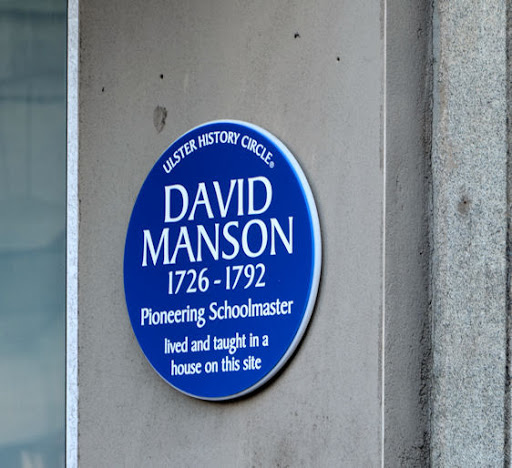
A plaque at the entrance to the Premier Inn J3374 : New hotel, Belfast, at the corner of Donegall Street and Waring Street, commemorating David Manson Link and Link. © Copyright Albert Bridge and...
- belfast
- people
- events
- hotel
- geograph
- city
- town centre
- blue plaque
Sixty-one years ago

The wet winter of 2013/14 with its frequent tidal surges and high river flows caused the Thames Barrier to be shut several times. This is one such occasion, on the early February spring...
- flood defence
- geograph
- thames barrier
- thames
- rivers
- streams
- drainage
To commemorate the opening of the Conwy Tunnel

© Copyright Ian S and licensed for reuse under this Creative Commons Licence . Submitted via Geograph
- paths
- estuary
- marine
- geograph
- north wales ...
- rivers
- streams
- drainage