

A plaque marking the opening of the Barnstaple Urban Relief Road

© Copyright Roger A Smith and licensed for reuse under this Creative Commons Licence . Submitted via Geograph
- city
- town centre
- roads
- road transport
- geograph
Stone outside the current Heritage Centre, Cape Clear Island

This building obviously used to be the school, but is now a museum. Unfortunately it was closed for the season at the time of our visit. See also V9622 : The Heritage Centre, Cape Clear Island...
- heritage centre
- educational sites
- geograph
- school (former)
- islands
Plaque on gateway, The Pemberton Almshouses

Plaque on the gateway of The Pemberton Almshouses (see TL1507 : Gateway, The Pemberton Almshouses). It reads "These six Alms Houses were Erected & Endowed With Five Pounds Pr. Annum Each Out of...
- pemberton almshouses
- almshouses
- housing
- dwellings
- roger pemberton
- geograph
- city
- town centre
- grade ii listed
- st albans
- gateway
Plaque, Norham Clock

The plaque is at the base of the Millennium Clock. For a wider view NT8947 : Clock, Norham © Copyright Maigheach-gheal and licensed for reuse under this Creative Commons Licence . Submitted via Geograph
- village
- rural settlement
- clock
- park and pub...
- geograph
- norham
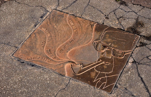
The Hepworth Wakefield - footbridge 1

Pedestrian access to the Hepworth from Thornes Lane, (where the car park for the gallery is located). The footbridge crosses the River Calder. Re the plaque in the pavement:-...
- educational sites
- art gallery
- famous person
- geograph
- human achievement
Plaque, Wesleyan Methodist Chapel

It states that the building was erected in 1838 Pictured here H9293 : 1st Mayola Scout Group Hall, Castledawson © Copyright Kenneth Allen and licensed for reuse under this Creative Commons Licence...
- religious sites
- geograph
Plaque, Castledawson Protestant Memorial Hall
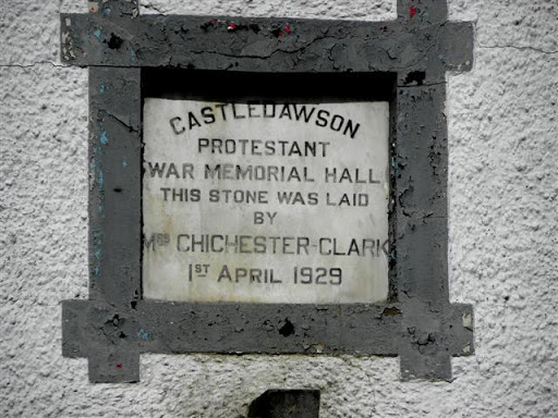
Pictured here H9293 : Castledawson Protestant Hall © Copyright Kenneth Allen and licensed for reuse under this Creative Commons Licence . Submitted via Geograph
- religious sites
- geograph
Plaque, Bellaghy Masonic Hall

Pictured here H9596 : Masonic Temperance Hall, Bellaghy © Copyright Kenneth Allen and licensed for reuse under this Creative Commons Licence . Submitted via Geograph
- public build...
- geograph
Plaque, Ladykirk and Norham Bridge

The plaque tells us that the bridge was built between 1885-7 by the Tweed Bridges Trust. © Copyright Maigheach-gheal and licensed for reuse under this Creative Commons Licence . Submitted via Geograph
- bridge
- geograph
- rivers
- streams
- drainage
- tweed
- roads
- road transport
- ladykirk
The Barbour memorial playings fields, Lisburn (2)
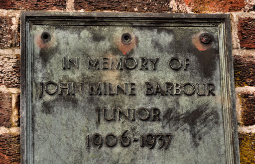
Part of the memorial plaque on the entrance gates J2763 : The Barbour memorial playing fields, Lisburn (1). © Copyright Albert Bridge and licensed for reuse under this Creative Commons Licence ....
- memorial plaque
- people
- events
- geograph
- sport
- leisure
- playing fields
- lisburn
- suburb
- urban fringe
D-Day commemorative trees, Innerleithen

Trees by the car park in Hall Street. A plaque on the stone plinth reads: Three Trees Were Planted By The Chairman Of Innerleithen Traquair & Glen Community Council On The 6th June 1994...
- park and pub...
- commemorativ...
- geograph
Rosamund Praeger plaque, Holywood

A plaque, in Hibernia Street, commemorating the sculptor Rosamund Praeger Link. Her works include Johnny the Jig J3979 : "Johnny the Jig", Holywood (1). See also J4079 : Praeger family grave,...
- people
- events
- geograph
- city
- town centre
- blue plaque
- holywood
Plaque, the Boyne Bridge, Belfast

A plaque, on the Boyne Bridge J3373 : The Boyne Bridge, Belfast marking its rebuilding in 1936. © Copyright Albert Bridge and licensed for reuse under this Creative Commons Licence . Submitted via Geograph
- bridge
- belfast
- people
- events
- geograph
- city
- town centre
- roads
- road transport
War Memorial, Preston

The war memorial plaque is set into the wall of the village hall. For a wider view of the building NT7957 : Village hall, Preston © Copyright Maigheach-gheal and licensed for reuse under...
- village
- rural settlement
- public build...
- village hall
- geograph
- war memorial
Memorial plaque, Preston

The plaque is set into the wall of the village hall. For a wider view of the building NT7957 : Village hall, Preston © Copyright Maigheach-gheal and licensed for reuse under this Creative...
- village
- rural settlement
- public build...
- village hall
- geograph
A plaque on the Anwoth and Girthon Millennium Cairn

This plaque lists the ministers of the United Charge of Anwoth and Girthon Parish Church from 1975 to the present day. For a view of the cairn, see NX5855 : A Millennium Cairn in the...
- lowlands
- geograph
- millennium cairn
A plaque on the Anwoth and Girthon Millennium Cairn

This plaque lists the ministers of Girthon Church since The Reformation (1560). For a view of the cairn, see NX5855 : A Millennium Cairn in the Boreland Hills. © Copyright Walter Baxter...
- lowlands
- geograph
- millennium cairn
A plaque on the Anwoth and Girthon Millennium Cairn

This plaque lists the ministers of Anwoth Church since The Reformation (1560). For a view of the cairn, see NX5855 : A Millennium Cairn in the Boreland Hills. © Copyright Walter Baxter...
- lowlands
- geograph
- millennium cairn
John Hewitt plaque, Belfast
A plaque, in the footpath, at the Crumlin Road end of Agnes Street commemorating the poet John Hewitt Link. He was born nearby at Cliftonpark Avenue and attended Agnes Street Methodist Primary...
- people
- events
- belfast
- suburb
- urban fringe
- geograph
Seipeil Dhonnain (St Donnan's Chapel)

A bilingual notice gives the history of the ruined chapel founded by Donnan on the shore of Loch Kishorn. © Copyright Tiger and licensed for reuse under this Creative Commons Licence ....
- religious sites
- geograph