

The Voyage on Nelson Street, Hull
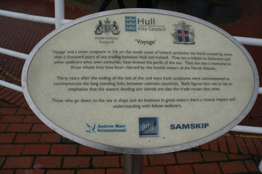
© Copyright Ian S and licensed for reuse under this Creative Commons Licence . Submitted via Geograph
- city
- town centre
- statue
- geograph
Plaque to Jack Brignall MBE
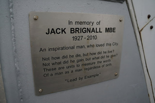
On the footbridge over the River Hull next to The Deep, Hull. © Copyright Ian S and licensed for reuse under this Creative Commons Licence . Submitted via Geograph
- memorial plaque
- city
- town centre
- geograph
Diamond Jubilee Plaque on Beverley Road

Market Weighton. © Copyright Ian S and licensed for reuse under this Creative Commons Licence . Submitted via Geograph
- geograph
- city
- town centre
- diamond jubilee
- diamond jubi...
- stone plaque
- queen elizab...
Golden Jubilee plaque on Beverley Road

Market Weighton © Copyright Ian S and licensed for reuse under this Creative Commons Licence . Submitted via Geograph
- stone plaque
- city
- town centre
- geograph
- golden jubilee
A convenient plaque

Presumably originally a fountain, 'Presented to the public by J. Hry. Burgess resident surgeon in this town 50 years and during his sixth mayorality 1864 and 1865'. Not now functional as a...
- lowlands
- village
- rural settlement
- glastonbury
- people
- events
- memorial dri...
- geograph
- public convenience
- somerset
Plaque by the Sandcastle, Withernsea

Situated along the sea wall near The Sandcastle on the Central Promenade is this plaque. It says the following:"Approximately 1 mile offshore from this port lies the site of the 13th Century...
- city
- town centre
- geograph
Blue Plaque

This one is on the corner of a building on Benedict Street in Glastonbury © Copyright Bill Nicholls and licensed for reuse under this Creative Commons Licence . Submitted via Geograph
- geograph
- city
- town centre
- historic sit...
- blue plaque
Albert Bridge plaque

Plaque on the grade II listed footbridge across the River Welland, built in 1881 to replace one destroyed by floods in 1880 THIS BRIDGE WAS ERECTED IN THE SECOND YEAR OF THE MAYORALTY OF JOHN...
- footbridge
- geograph
- historic sit...
- grade ii listed
Plaque, St Eugene's hall

Pictured here H3480 : St. Eugene's Church Hall © Copyright Kenneth Allen and licensed for reuse under this Creative Commons Licence . Submitted via Geograph
- religious sites
- geograph
Plaque at entrance to Upnor Castle House

This plaque on Upchat Road near the junction with Upnor Road is next to the gates for Upnor Castle House. Queen Elizabeth I is standing in front of Upnor Castle during a thunderstorm! For more...
- people
- events
- geograph
PLUTO Memorial on Shanklin Esplanade

PLUTO stands for Pipeline under the Ocean. For some more info see Link . © Copyright Barry Shimmon and licensed for reuse under this Creative Commons Licence . Submitted via Geograph
- memorial
- historic sit...
- coastal
- geograph
St Peter, South Somercotes, Lincolnshire

© Copyright Ian S and licensed for reuse under this Creative Commons Licence . Submitted via Geograph
- village
- rural settlement
- religious sites
- geograph
- church
Tetney, best kept village 2012

© Copyright Ian S and licensed for reuse under this Creative Commons Licence . Submitted via Geograph
- village
- rural settlement
- geograph
- jubilee gardens
The site of the former RAF Grimsby (Waltham)

© Copyright Ian S and licensed for reuse under this Creative Commons Licence . Submitted via Geograph
- defence
- military
- former raf airfield
- information plaque
- air transport
- geograph
- historic sit...
Muckle Roe: bridge plaques

These two stones stand at a lay-by alongside HU3465 : Muckle Roe: leaving the island by road. The nearer one states: MUCKLE ROE BRIDGE Widened and strengthened by Zetland County Council Opened on...
- islands
- geograph
- roads
- road transport
- bridge
The plaque on East Park Gates

© Copyright Ian S and licensed for reuse under this Creative Commons Licence . Submitted via Geograph
- defence
- military
- park and pub...
- historic sit...
- geograph
Owbridge Court, Midland Street
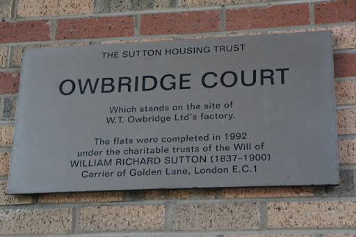
On the site of Owbridge cough medicine factory. The flats were built by Sewell's of Hull. © Copyright Ian S and licensed for reuse under this Creative Commons Licence . Submitted via Geograph
- flats
- city
- town centre
- housing
- dwellings
- geograph
Harvest Lodge, The Greenway, Hull
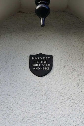
© Copyright Ian S and licensed for reuse under this Creative Commons Licence . Submitted via Geograph
- name plaque
- suburb
- urban fringe
- housing
- dwellings
- geograph
Plaque marking former site of chapel

No traces of the foundations are now apparent on the ground. See NN6008 : Kilmahog Burial Ground for context; the same plaque is clearly visible in that picture. © Copyright Lairich Rig and...
- burial ground
- crematorium
- historic sit...
- geograph
Plaque on Sibton Bench

Off the A1120 Yoxford Road near Sibton Nursery School This bench is provided by Sibton Parish Council to commemorate the Diamond Jubilee of Her Majesty Queen Elizabeth II © Copyright Adrian Cable...
- village
- rural settlement
- a1120
- her majesty ...
- yoxford road
- the a1120 yo...
- parish council
- geograph
- a1120 yoxford road
- bench
- sibton
- closeup
- diamond jubilee
- nursery school
- sibton bench
- sibton paris...
- sibton nurse...