

Plaque, Rockcorry Methodist Church

The inscription reads, "AD 1807 Methodist Chapel. Under the Patronage T.C. Stewart Corry. Esq. M.P." Pictured here H6419 : Former Methodist Church, Rockcorry © Copyright Kenneth Allen and...
- religious sites
- geograph
Black Friars Gate, Canterbury

See: Link for more information. © Copyright Becky Williamson and licensed for reuse under this Creative Commons Licence . Submitted via Geograph
- gate
- historic sit...
- geograph
Plaque, "Widows Row"

One of two H6419 : The Terrace, Rockcorry - the following inscription is marked on each one. "These houses were erected by Joseph Griffith, Esq. for Destitute Widows AD 1847" © Copyright Kenneth...
- housing
- dwellings
- geograph
Plaque, Lisnagrieve National School

Pictured here H8126 : Lisnagrieve National School © Copyright Kenneth Allen and licensed for reuse under this Creative Commons Licence . Submitted via Geograph
- educational sites
- geograph
Plaque, Moys National School

Pictured here H7430 : Moys National School © Copyright Kenneth Allen and licensed for reuse under this Creative Commons Licence . Submitted via Geograph
- educational sites
- geograph
Edward Brice plaque, Ballycarry (2)

See J4493 : Edward Brice plaque, Ballycarry (1). The plaque in its setting with the ruins of Templecorran old church in the background. © Copyright Albert Bridge and licensed for reuse under this...
- village
- rural settlement
- people
- events
- religious sites
- geograph
- church (ruined)
- blue plaque
- ballycarry
Plaque on Shap Market House

Set in one of the blocked up upper windows, and you have to stand in the middle of Main Street to read it. © Copyright Martin Dawes and licensed for reuse under this Creative Commons Licence...
- market house...
- geograph
- city
- town centre
- historic sit...
- roads
- road transport
Aneurin Bevan Plaque, Tredegar

Aneurin 'Nye' Bevan was born in Tredegar in 1897. This plaque remembers that he was the architect of the National Health Service which was established in 1948. The quotation on the plaque is All...
- tredegar
- aneurin bevan
- city
- town centre
- geograph
Edward Brice plaque, Ballycarry (1)

A plaque, close to Templecorran old church, commemorating Edward Brice. It reads This plaque was erected on September 5th 1993 to mark the 380th anniversary of the ministry in this village of...
- village
- rural settlement
- people
- events
- religious sites
- geograph
- blue plaque
- ballycarry
Plaque, Lisglassan Mass garden

Pictured here H7530 : Lisglassan Mass garden © Copyright Kenneth Allen and licensed for reuse under this Creative Commons Licence . Submitted via Geograph
- religious sites
- geograph
Lych gate plaque, Locking

The plaque is on this Link lych gate. © Copyright Jaggery and licensed for reuse under this Creative Commons Licence . Submitted via Geograph
- village
- rural settlement
- religious sites
- geograph
GWR anniversary plaque, Taunton railway station

The Taunton Deane plaque commemorating the 150th anniversary of the Great Western Railway in 1985 is fixed to the wall on platform 2. The plaque also records the arrival of the first...
- railways
- geograph
A Better Class of Person

Plaque commemorating Bob Cooney in the Castlegate. Unlike most such plaques, it does not mark Bob's house, but his political activities in Aberdeen, and one famous incident in particular:...
- people
- events
- geograph
- fascism
- city
- town centre
- political activity
Prince's Bridge, Manchester-Salford
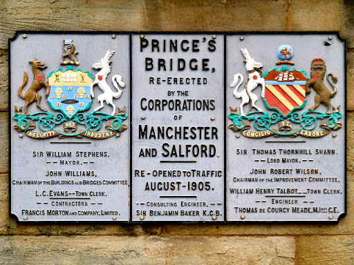
Prince's Bridge crosses the River Irwell which is traditionally the boundary between the cities of Manchester and Salford. This plaque (dated 1906) marks that boundary. © Copyright David Dixon...
- boundary marker
- boundary
- barrier
- geograph
- coat of arms
- manchester c...
- city
- town centre
- closeup
- motto
- integrity an...
- 1905
- concilio et labore
- salford corporation
Plaque on wall of former Midland Bank Building, Poultry, London EC2

© Copyright Christine Matthews and licensed for reuse under this Creative Commons Licence . Submitted via Geograph
- city
- town centre
- historic sit...
- geograph
Plaque, Memorial Garden, Alresford, Hampshire

Plaque in Memorial Garden, which was given to the town by Sir Francis Lindley in 1951. The plaque in memory of residents of New Alresford, who gave their lives in World War II 1939-1945. ©...
- village
- rural settlement
- memorial
- public build...
- geograph
- rivers
- streams
- drainage
Plaque, Ardaghey Forge

The following wording is included in the text, "Ardaghey Forge. The Forge was built in 1898 and was strategically located at Ardaghey Cross. Paddy Murphy, Mullinabattog was the blacksmith...
- historic sit...
- geograph
Plaque, Memorial Garden, Alresford, Hampshire

Plaque in Memorial Garden, giving information about the donation of this land to the town by Sir Francis Lindley in 1951. There are two plaques near the entrance in memory of residents of...
- village
- rural settlement
- memorial
- public build...
- garden
- geograph
Plaque, Memorial Garden, Alresford, Hampshire

Plaque in Memorial Garden, which was given to the town by Sir Francis Lindley in 1951. The plaque in memory of residents of New Alresford, who gave their lives in the Great War 1914 - 1918....
- village
- rural settlement
- memorial
- public build...
- geograph
- rivers
- streams
- drainage
Plaque on house in Broad Street, Alresford, Hampshire

Plaque commemorating that this house was the headquarters of the 47th Infantry Regiment, 9th Division of the United States Army from 1943 to D-Day June 1944. © Copyright Christine Matthews and...
- village
- rural settlement
- defence
- military
- housing
- dwellings
- geograph
- roads
- road transport